


- 2:00 h
- 6.22 km
- 169 m
- 169 m
- 1,166 m
- 1,336 m
- 170 m
- Start: Mund (1223 m)
- Destination: Mund
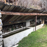
This hike takes you along the Suone Stigwasser first from Mund into the Gredetschtal and via the Suone Obersta to Birgisch. The irrigation channels, some of which lead through spectacular terrain and steep rocky sections, are both located in the Gredetschtal valley near the Mundbach stream at an altitude of approx. 1300 m. They were used for a long time to irrigate the fields and meadows in Mund and Birgisch.

Good to know
Pavements
Best to visit
Directions
You hike through small, wildly romantic tunnels and in the middle of the path you catch sight of the Matterhorn on the horizon. Slowly the valley opens up again and soon you have a clear view of the Rhone plain. The path coming from Belalp brings you to the hamlet of Oberbirgisch. From here you follow a melioration road in the direction of Birgisch. Via Mundchi you return to Mund.
If you still feel like it and have some energy left, you can visit the saffron museum in Mund and learn about the red gold.
Mund - Tähischinu - right-hand path towards Stigwasser - Üssers Sänntum - Obersta - Birgisch - Mundchi - Mund
Tour information
Cultural Interesting
Loop Road
Stop at an Inn
Equipment
Directions & Parking facilities
From western Switzerland: A9 Lausanne - Vevey, or north-western Switzerland: A12 Bern - Vevey: A9 - Sierre: main road Sierre - Brig
From north-western Switzerland: A6 Berne - Thun - Spiez: main road Spiez - Kandersteg (Lötschberg tunnel car transport) - Goppenstein - Gampel - Brig
From eastern and central Switzerland: Andermatt - Realp (year-round Furka car transport; in summer via Furka Pass) - Oberwald - Brig
From Ticino (in summer): Airolo - Nufenenpass - Ulrichen - Brig
Or via Centovalli - Domodossola - Simplonpass - Brig
From Italy (Aosta, Mt. Blanc Tunnel): Aosta - Grand Saint Bernard tunnel (over the pass in summer) - Martigny: A9 motorway - Sierre: Sierre - Brig main road.
Or via Domodossola - Simplon Pass - Brig
Mund
From Brig you can reach Mund via Naters
You can find the timetable and further information on how to get there at: www.belalp.ch
Additional information
Belalp Bahnen AG
Blatten - Belalp Tourismus AG
Author´s Tip / Recommendation of the author
- Enjoy the beautiful and unique view of the Matterhorn
Safety guidelines
Especially in autumn, you should also be aware that leaves lying on the ground can hide bumps, roots, stones or holes in the path. After storms, trees can still fall over or branches can fall down. Especially in adverse weather conditions, muddy and slippery passages can occur on natural paths. You have to expect this kind of path obstruction when you go on a hike.
Not all rocks or precipices are secured with ropes or railings. In some cases surefootedness is required. If you think that certain sections of the trail are not passable for you, you should avoid them.
Nearby


