


- 2:50 h
- 7.46 km
- 349 m
- 350 m
- 1,201 m
- 1,514 m
- 313 m
- Start: Mund, bus stop (1203 m)
- Destination: Mund, bus stop (1203 m)
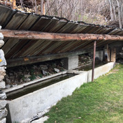
Along the spectacular Suone Wyssa, this hike first takes you from Mund along steep rock faces and through 16 tunnels to the stony meadows of the Gredetschtal. The Wyssa was first mentioned in a document around 1462 and its builders had to attach it to the rock under difficult conditions.
In 1928/29, the Suone was renovated and its course was partly relocated into tunnels; in 1998, a modern water tunnel was built. This is located next to the entrance to the Suonenweg and is an alternative for hikers who are afraid of heights.
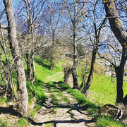
The hike back to Mund first follows the Mundbach stream and then turns off onto the Suone Stigwasser. With a minimal descent, it goes along the Suone back to the starting point of the hike.
The irrigation channels, some of which lead through spectacular terrain and steep rocky sections, are both located in the Gredetschtal valley near the Mundbach stream at about 1,300 m above sea level and were used for a long time to irrigate the fields and meadows in Mund and Birgisch.
Note
The trail leads along the bisses, sometimes along steep cliffs, and should therefore be walked with caution; a head for heights is required. Younger children should be roped up. You walk through several narrow tunnels, which is why a torch is useful.

Good to know
Pavements
Best to visit
Directions
The hike starts at the bus stop Mund Dorf and leads through the narrow streets of the typical Valais mountain village to Roosse. Here the hiking trail net branches out. Continue in the direction of the Suone Wyssa. Soon you are in front of the water tunnel built in 1998. Hikers who are not afraid of heights are recommended to use the route through the tunnel.
Follow the path and you will soon reach the "Üssers Senntum" in the Gredetschtal. Hike along the Mundbach stream down the valley and continue the hike on the path that follows the Suone Stigwasser. This path brings you back to Mund.
Mund - Dichtuhüs - Ewigschmatte - Üssers Senntum - Wyssa - Gredetschtal - Mundbach - Üssers Senntum - Breite Acher - Mund
Tour information
Cultural Interesting
Loop Road
Equipment
Directions & Parking facilities
From western Switzerland: A9 Lausanne - Vevey, or north-western Switzerland: A12 Bern - Vevey: A9 - Sierre: main road Sierre - Brig
From north-western Switzerland: A6 Berne - Thun - Spiez: main road Spiez - Kandersteg (Lötschberg tunnel car transport) - Goppenstein - Gampel - Brig
From eastern and central Switzerland: Andermatt - Realp (year-round Furka car transport; in summer via Furka Pass) - Oberwald - Brig
From Ticino (in summer): Airolo - Nufenenpass - Ulrichen - Brig
Or via Centovalli - Domodossola - Simplonpass - Brig
From Italy (Aosta, Mt. Blanc Tunnel): Aosta - Grand Saint Bernard tunnel (over the pass in summer) - Martigny: A9 motorway - Sierre: Sierre - Brig main road.
Or via Domodossola - Simplon Pass - Brig
Birgisch / Mund
From Brig you can reach Birgisch and Mund bia Naters.
You can find the timetable and further information on how to get there at: www.belalp.ch
Additional information
If you have any questions, please contact:
Belalp Bahnen AG
Blatten - Belalp Tourismus AG
Author´s Tip / Recommendation of the author
Visit the Saffron Museum in Mund.
A torch is recommended for walking the tunnels.
Safety guidelines
The trail follows the Suonen partly along steep rocky precipices and is therefore to be walked with caution, free from vertigo is required. You walk through several narrow tunnels, which is why a torch is handy.
Despite the "untraceable" marking of the hiking trails, we recommend for safety reasons to always have an appropriate hiking map with you, so that you can quickly find your way to a safe area in case of a thunderstorm or emergency, for example.
Especially in autumn, you should also be aware that leaves lying on the ground can hide bumps, roots, stones or holes in the path. After storms, trees can still fall over or branches can fall down. Especially in adverse weather conditions, muddy and slippery passages can occur on natural paths. You have to expect this kind of path impairment when you go on a hike.
Not all rocks or precipices are secured with ropes or railings. In some cases surefootedness is required. If you are of the opinion that certain sections of the trail are not passable for you, you should avoid them.
Nearby


