


- 0:45 h
- 831 m
- 161 m
- 2,140 m
- 2,300 m
- 160 m
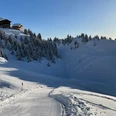
- Start: Bruchegg, Belalp
- Destination: Schönbiel, Belalp
The winter hike starts at the valley station of the Sparrhorn chairlift in the direction of Schönbiel (2300 m a.s.l.) Below the chairlift, take the path to the left. From here you climb up the path to the Schönbiel mountain station. The winter hiking trail is located next to the downhill slope. The hike takes about 45 minutes.
Once you arrive at Schönbiel, you can enjoy the sunshine and refreshments at Ricco's Igloo. From Schönbiel you have a wonderful panoramic view of the wintry Belalp and the Valais mountains.
There are several options for the way back. You can get to the starting point of your winter hike with the Bruchegg chairlift or via the winter hiking trail. If you would like to go down to Chiematte and the top station of the gondola lift, you can either use the Kelchbach chairlift or take the Weisse Meile winter hiking trail.

Good to know
Pavements
Best to visit
Directions
Tour information
Stop at an Inn
Equipment
Directions & Parking facilities
From western Switzerland: A9 Lausanne - Vevey, or north-western Switzerland: A12 Bern - Vevey: A9 - Sierre: main road Sierre - Brig
From north-western Switzerland: A6 Berne - Thun - Spiez: main road Spiez - Kandersteg (Lötschberg tunnel car transport) - Goppenstein - Gampel - Brig
From eastern and central Switzerland: Andermatt - Realp (year-round Furka car transport; in summer via Furka Pass) - Oberwald - Brig
From Ticino (in summer): Airolo - Nufenenpass - Ulrichen - Brig
Or via Centovalli - Domodossola - Simplonpass - Brig
From Italy (Aosta, Mt. Blanc Tunnel): Aosta - Grand Saint Bernard tunnel (over the pass in summer) - Martigny: A9 motorway - Sierre: Sierre - Brig main road.
Or via Domodossola - Simplon Pass - Brig
Blatten bei Naters
From Brig you can reach Blatten bei Naters via Naters, then take the cable car to the car-free Belalp.
You can find more information at: www.belalp.ch
You can find the timetable and further information on how to get there at: www.belalp.ch
Additional information
Author´s Tip / Recommendation of the author
Safety guidelines
Use of the snowshoe routes and information on this website is at your own risk. The conditions on site may cause changes to the route. Blatten-Belalp Tourism accepts no responsibility for the accuracy or completeness of the information on this website.
- Carry a map with you. Download the complete description of the trail with a large scale map by clicking on " Print " at the top right of the page.
- Use only marked trails and obey all signs and instructions - for your own safety, to protect grazing animals and out of respect for wildlife.
- Be considerate of other trail users and the landscape. Take their litter and that of others with you.
- Take extra sun protection with you. UV rays at high altitudes can be very strong, especially in winter, even in overcast weather.
Nearby


