BELALP - ALPE BÄLL - BLATTEN BEI NATERS


- 1:30 h
- 4.52 km
- 764 m
- 1,332 m
- 2,096 m
- Difficulty: medium
- Start: Belalp, mountain station aerial cableway
- Destination: Blatten bei Naters
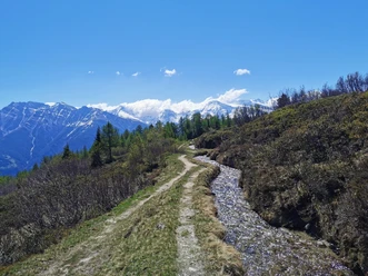
From the mountain station of the shuttle lift, you can reach Alpe Bäll in about 15 minutes.
Afterwards, the hike leads into Antoniuswald. Enjoy the silence and delight in the beauty and scent of the forest. After passing through the Tschuggen holiday settlement, the hiking trail leads through lush meadows down to Blatten, where you can treat yourself to something nice in one of the restaurants.

Good to know
Pavements
Best to visit
Directions
The hike begins at the mountain station of the shuttle lift and initially leads down the connecting road to Alpe Bäll. Following the signage, you turn right off the road below Alpe Bäll and now enter the Antoniuswald. The path leads down into the Tschuggen holiday settlement. At the lower end of the settlement (before the large gate), turn right again and follow the signs to Blatten. After reaching the road, follow it for a short moment before the hiking trail turns off to the right again after a hairpin bend and leads down to Blatten bei Naters.
Tour information
Stop at an Inn
Equipment
Sturdy footwear, weather-appropriate clothing, sun and rain protection, as well as sufficient supplies of food and drinks, are recommended in case there are no open places to stop or buy supplies. Although the trail is very well marked throughout, for safety reasons you should always carry a suitable hiking map. Bring poles or other aids.
Directions & Parking facilities
Arrival by car
From Western Switzerland: A9 Lausanne - Vevey, or Northwestern Switzerland: A12 Bern - Vevey: A9 - Sierre: Main road Sierre - Brig
From Northwestern Switzerland: A6 Bern - Thun - Spiez: Main road Spiez - Kandersteg (car shuttle Lötschberg tunnel) - Goppenstein - Gampel - Brig
From Eastern and Central Switzerland: Andermatt - Realp (year-round car shuttle Furka; in summer via Furka pass) - Oberwald - Brig
From Ticino (in summer): Airolo - Nufenen Pass - Ulrichen – Brig
Or via Centovalli – Domodossola – Simplon Pass – Brig
From Italy (Aosta, Mt. Blanc Tunnel): Aosta - Grand Saint Bernard Tunnel (in summer over the pass) - Martigny: Motorway A9 - Sierre: Main road Sierre – Brig
Or via Domodossola – Simplon Pass – Brig
Blatten bei Naters
From Brig you reach Blatten bei Naters via Naters, then take the aerial cableway to the car-free Belalp.
Paid parking is available at Chienzlichrommu and the parking garage in Blatten bei Naters.
More information can be found at:
Blatten bei Naters is accessible by public transport from Brig or Naters.
You can reach Belalp from Blatten by aerial cableway.
Additional information
If you have any questions, please contact:
Belalp Bahnen AG
bahnen@belalp.ch
+41 (0)27 921 65 10
Blatten - Belalp Tourismus AG
tourismus@belalp.ch
+41 (0)27 921 60 40
Author´s Tip / Recommendation of the author
The hike is also suitable for children.
Safety guidelines
Despite the “unmistakable” marking of the hiking trails, we recommend always carrying a suitable hiking map for safety reasons, so that in the event of a thunderstorm or emergency you can quickly find a safe area.
Especially in autumn, note that fallen leaves on the ground can conceal unevenness, roots, stones or holes in the path. After storms, trees may still fall or branches break off. Particularly in bad weather conditions, natural paths can have muddy and slippery sections. You should expect impairments of this kind when hiking.
Not all rocks or precipices are secured with ropes or railings. Sure-footedness is sometimes required. If you consider certain sections impassable, you should bypass them.
Nearby


.jpg")

