- 4:55 h
- 11.33 km
- 916 m
- 916 m
- 2,095 m
- 3,008 m
- Difficulty: difficult
- Start: Belalp, Belalp Bahnen mountain station (2095 m)
- Destination: Belalp, Belalp Bahnen mountain station
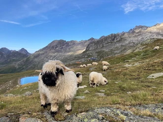
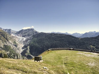
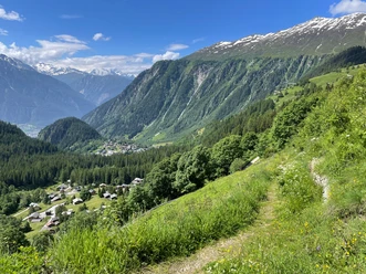
The hike leads through lush alpine meadows, past the Lüsgersee and via the Tyndall Monument and Hohbiel up to the Sparrhorn. The ascent poses no great difficulties and is also suitable for surefooted children. It is worthwhile repeatedly enjoying the view of the fantastic mountain world of the Valais Alps along the way. From the summit of the Sparrhorn at 3021 m above sea level, a panoramic view opens up: the peaks of the Fusshörner are within reach, below you can see the Oberaletsch Glacier, and in the distance are among others the distinctive four-thousanders Matterhorn, Weisshorn, Dom, and Monte Rosa.

Pavements
- Asphalt (1%)Gravel (1%)Trail (25%)Path (73%)
Best to visit
- suitableDepends on weather
Directions
From the Belalp mountain station, follow the road eastwards until you reach Bruchegg. Here, turn left and walk above the Lüsgersee to the Tyndall Monument. Continue along the signs up to the Hohbiel. From here, several steep switchbacks follow, and finally, you climb a gravel-covered slope up to the summit. Surefootedness required.
The descent is mostly along the same route. At the Tyndall Monument, you can also choose the direct descent to Hotel Belalp on the Aletschbord.
Belalp - Lüsga - Hotel Belalp - Chapel Lüsgen - Tyndall Monument - Hohbiel - Sparrhorn - Tyndall Monument - Aletschbord - Bruchegg - Belalp
Tour information
Circular trail
Mountain summit
Refreshment stop
Equipment
Sturdy footwear, weather-appropriate clothing, sun and rain protection, as well as sufficient food and drinks, should be carried, as there may be no places to stop or shop open. Although the path is very well marked throughout, for safety reasons you should always carry a suitable hiking map. Bring poles or other aids.
Directions & Parking facilities
- Getting there
Arrival by car
From Western Switzerland: A9 Lausanne - Vevey, or Northwestern Switzerland: A12 Bern - Vevey: A9 - Sierre: Main road Sierre - Brig
From Northwestern Switzerland: A6 Bern - Thun - Spiez: Main road Spiez - Kandersteg (car transport Lötschberg tunnel) - Goppenstein - Gampel - Brig
From Eastern and Central Switzerland: Andermatt - Realp (year-round car transport Furka; in summer over Furka pass) - Oberwald - Brig
From Ticino (in summer): Airolo - Nufenenpass - Ulrichen – Brig
Or via Centovalli – Domodossola – Simplon pass – Brig
From Italy (Aosta, Mt. Blanc Tunnel): Aosta - Tunnel Grand Saint Bernard (in summer over the pass) - Martigny: Motorway A9 - Sierre: Main road Sierre – Brig
Or via Domodossola – Simplon pass – Brig
Blatten bei Naters
From Brig you reach Blatten bei Naters via Naters, then from there take the aerial cableway to the car-free Belalp.
ParkingPaid parking is available at Chienzlichrommu and in the car park in Blatten bei Naters.
Further information can be found at:
Public transportationBlatten bei Naters can be reached from Brig or Naters by public transport www.sbb.ch
You reach Belalp from Blatten by aerial cableway.
Timetable and further information on arrival can be found at: www.belalp.ch
Additional information
If you have questions, please contact:
Belalp Bahnen AG
Blatten - Belalp Tourismus AG
Author´s Tip / Recommendation of the author
- Sign the summit register
- Enjoy the unique view
- Visit the Lüsgersee and treat yourself to a refreshing swim
Safety guidelines
Despite the "impossible to lose" marking of the hiking trails, we recommend always carrying an appropriate hiking map for safety reasons, so that, for example, in the event of a thunderstorm or emergency, you can quickly find a safe area.
Especially in autumn, note that fallen leaves on the ground can cover unevenness, roots, stones, or holes in the path. After storms, trees can still fall or branches can break off. Particularly under adverse weather conditions, natural paths can become muddy and slippery. You should expect such path impairments when hiking.
Not all rocks or cliffs are secured with ropes or railings. Surefootedness is sometimes required. If you believe certain sections are impassable for you, you should avoid them.