BELALP - OBERALETSCH HUT


- 4:30 h
- 10.03 km
- 824 m
- 280 m
- 1,969 m
- 2,693 m
- Difficulty: difficult
- Start: Mountain station Belalp (2094 m)
- Destination: Mountain station Belalp
The Oberaletsch Hut, a solid stone house at the foot of the Fusshörner at 2640 m above sea level, lies in the middle of the alpine glacier area of the UNESCO World Heritage Swiss Alps Jungfrau-Aletsch.
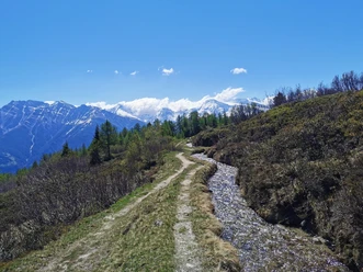
The ascent starts at the mountain station of the cable car (2094 m above sea level) and leads via Hotel Belalp down over the famous "Steigglen" to the alpine pastures of the Outer Aletschji. After crossing the Oberaletsch gorge, the path climbs and goes up over the glacier moraine.
From there, the comfortable path then leads high above the Oberaletsch glacier valley inward towards the hut. It crosses several steep gullies, partly secured with ropes. During this, the impressive scenery opens up with views of the Oberaletsch Hut (2640 m above sea level). The path is a mountain hiking trail T3.
The return journey takes the same route.

Good to know
Pavements
Best to visit
Directions
The hike starts at the mountain station of the aerial cableway and initially leads you on a wide path to the Hotel Belalp and the Aletschbord. Here follows the descent via the “Steigglen” to the “Üssers Aletschji”. After a longer traverse under the rugged rocks of the "Bord", you climb towards a rocky ridge. Afterwards, you proceed along the slope to the southern, old moraine of the Oberaletschgletscher and continue along the path down into the impressive gorge, across the bridge and up onto the moraine ridge "Lochegga". The path takes you over the moraine up to its end and then steeply up to about 2600 m. Over the panorama path (built in 2005) you finally reach the hut.
Mountain station Belalp - Aletschbord - Oberaletsch Hut - Mountain station Belalp
Tour information
Barrier-Free
Stop at an Inn
Equipment
Sturdy footwear, weather-appropriate clothing, sun and rain protection, as well as a sufficient supply of food and drinks, are necessary as there may be no dining or shopping facilities available or open. Although the path is consistently very well marked, for safety reasons you should always have a suitable hiking map with you. Bring trekking poles or other aids.
Directions & Parking facilities
Arrival by car
From Western Switzerland: A9 Lausanne - Vevey, or Northwest Switzerland: A12 Bern - Vevey: A9 - Sierre: Main road Sierre - Brig
From Northwest Switzerland: A6 Bern - Thun - Spiez: Main road Spiez - Kandersteg (car shuttle Lötschberg tunnel) - Goppenstein - Gampel - Brig
From Eastern and Central Switzerland: Andermatt - Realp (year-round car shuttle Furka; in summer via Furka Pass) - Oberwald - Brig
From Ticino (in summer): Airolo - Nufenen Pass - Ulrichen – Brig
Or via Centovalli – Domodossola – Simplon Pass – Brig
From Italy (Aosta, Mt. Blanc Tunnel): Aosta - Grand Saint Bernard Tunnel (in summer via the pass) - Martigny: Motorway A9 - Sierre: Main road Sierre – Brig
Or via Domodossola – Simplon Pass – Brig
Blatten bei Naters
From Brig you reach Blatten bei Naters via Naters, then with the aerial cableway to the car-free Belalp.
Paid parking is available at Chienzlichrommu and in the car park in Blatten bei Naters.
Further information can be found at:
Blatten bei Naters can be reached from Brig or Naters by public transport www.sbb.ch.
You reach Belalp from Blatten by aerial cableway.
The timetable and further information on how to get there can be found at: www.belalp.ch
Additional information
If you have questions, please contact:
Belalp Bahnen AG
Blatten - Belalp Tourism AG
Author´s Tip / Recommendation of the author
After the strenuous ascent, the beer at the hut tastes even better.
An overnight stay at the hut is highly worthwhile and makes the route a special (mountain) experience.
Reservation and information at www.oberaletsch.ch
Safety guidelines
Despite the “unmissable” marking of the hiking trails, we recommend always carrying a corresponding hiking map for safety reasons, so that in the event of a thunderstorm or emergency you can quickly find a safe area.
Especially in autumn, it is also important to be aware that fallen leaves on the ground can conceal unevenness, roots, stones or holes in the path. After storms, trees can still fall or branches drop afterwards. Especially in adverse weather conditions, natural paths can have muddy and slippery sections. You must expect such path impairments if you go hiking.
Not all rocks or abysses are secured with ropes or railings. Surefootedness is partly required. If you think certain path sections are not passable for you, you should bypass them.
Nearby


