- 2:15 h
- 5.74 km
- 471 m
- 470 m
- 1,592 m
- 2,063 m
- 471 m
- Start: Salwald
- Destination: Salwald
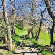
The hike begins leisurely in the Salwald above Mund and first leads to the settlement of Chaschtler. From Chaschtler, the actual ascent to Alpe Brischeru then begins. Look back from time to time and take a look at the Valais mountains.
Once you arrive at Brischeru, a panorama opens up from the Dents du Midi to the Goms. Enjoy the view of the mighty Fletschhorn, the Mischabel group, the Matterhorn and the radiant Weisshorn.
Take a well-deserved break here before starting the descent to Salwald on the east side of Brischeru.

Good to know
Pavements
Best to visit
Directions
Tour information
Loop Road
Stop at an Inn
Equipment
Directions & Parking facilities
From western Switzerland: A9 Lausanne - Vevey, or north-western Switzerland: A12 Bern - Vevey: A9 - Sierre: main road Sierre - Brig
From north-western Switzerland: A6 Berne - Thun - Spiez: main road Spiez - Kandersteg (Lötschberg tunnel car transport) - Goppenstein - Gampel - Brig
From eastern and central Switzerland: Andermatt - Realp (year-round Furka car transport; in summer via Furka Pass) - Oberwald - Brig
From Ticino (in summer): Airolo - Nufenenpass - Ulrichen - Brig
Or via Centovalli - Domodossola - Simplonpass - Brig
From Italy (Aosta, Mt. Blanc Tunnel): Aosta - Grand Saint Bernard tunnel (over the pass in summer) - Martigny: A9 motorway - Sierre: Sierre - Brig main road.
Or via Domodossola - Simplon Pass - Brig
Blatten bei Naters
From Brig you can reach Blatten bei Naters via Naters, then take the cable car to the car-free Belalp.
Author´s Tip / Recommendation of the author
Safety guidelines
Especially in autumn, you should also be aware that leaves lying on the ground can hide bumps, roots, stones or holes in the path. After storms, trees can still fall over or branches can fall down. Especially in adverse weather conditions, muddy and slippery passages can occur on natural paths. You have to expect this kind of path obstruction when you go on a hike.
Not all rocks or precipices are secured with ropes or railings. In some cases surefootedness is required. If you think that certain sections of the trail are not passable for you, you should avoid them.
Nearby