MUND - BIRGISCH - NATERS


- 1:45 h
- 5.89 km
- 11 m
- 517 m
- 681 m
- 1,198 m
- Difficulty: medium
- Start: Mund
- Destination: Naters
This hike starts in the saffron village of Mund. Mund is the only place in Switzerland where the spice saffron is still cultivated today after centuries of tradition. The Crocus Savitus grows here on the sunny plateau and is harvested during the season between October and November. Between 30 and 1000 flowers are picked per day, and the precious spice is obtained from the stigmas of their blossoms.
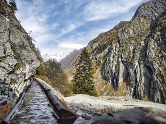
The hike leads from here a bit into the Gredetsch valley before the path crosses the Mundbach at Mundchi and continues along the mountain to Birgisch. Once in Birgisch, it is worth taking a short detour to the chapel to admire the 14th-century crucifix.
Now follows the actual descent to Naters. On the last few meters down to Naters, follow the Way of the Cross, which visually portrays the path of Jesus' passion, from his arrest in the Garden of Gethsemane to his death on the cross.

Good to know
Pavements
Best to visit
Directions
From Mund, follow the signpost into the Gredetsch valley to Mundchi and from there to Birgisch. From here, follow the main road briefly before turning right onto the hiking trail. The path runs along the road once more before finally splitting off and descending towards Naters.
Tour information
Stop at an Inn
Equipment
Sturdy footwear, weather-appropriate clothing, sun and rain protection, as well as sufficient food and drink supplies, should be taken in case no dining or shopping options are available or open. Although the trail is very well marked throughout, for safety reasons, you should always carry a suitable hiking map. Bring poles or other aids.
Directions & Parking facilities
Arrival by car
From Western Switzerland: A9 Lausanne - Vevey, or Northwestern Switzerland: A12 Bern - Vevey: A9 - Sierre: Main road Sierre - Brig
From Northwestern Switzerland: A6 Bern - Thun - Spiez: Main road Spiez - Kandersteg (car shuttle Lötschberg tunnel) - Goppenstein - Gampel - Brig
From Eastern and Central Switzerland: Andermatt - Realp (year-round car shuttle Furka; in summer over Furka pass) - Oberwald - Brig
From Ticino (in summer): Airolo - Nufenen pass - Ulrichen – Brig
Or via Centovalli – Domodossola – Simplon pass – Brig
From Italy (Aosta, Mt. Blanc Tunnel): Aosta - Grand Saint Bernard tunnel (in summer over the pass) - Martigny: motorway A9 - Sierre: Main road Sierre - Brig
Or via Domodossola – Simplon pass – Brig
Birgisch / Mund
From Brig you reach Birgisch and Mund via Naters.
Parking is available next to the church and the bus stop in Mund.
Take the post bus to Mund village and start your route there.
You can find the timetable and further travel information at: www.belalp.ch
Additional information
If you have questions, contact:
Belalp Bahnen AG
Blatten - Belalp Tourismus AG
Author´s Tip / Recommendation of the author
Visit the Restaurant Safran in Mund or the Restaurant Birgisch in Birgisch.
Safety guidelines
Despite the "unmistakable" marking of the hiking trails, we recommend always carrying a suitable hiking map for safety reasons so that, for example, in a thunderstorm or emergency you can quickly find a safe area.
Especially in autumn, be aware that fallen leaves on the ground can conceal unevenness, roots, stones, or holes in the path. After storms, trees can still topple or branches fall afterwards. Especially in adverse weather conditions, natural paths can have muddy and slippery sections. You should expect such path impairments when undertaking a hike.
Not all rocks or abysses are secured with ropes or railings. Surefootedness is partly required. If you consider certain trail sections impassable, you should bypass them.
Nearby