IRRIGATION CHANNEL HIKE STIGWASSER AND OBERSTA INTO THE GREDETSCHTAL


- 2:00 h
- 6.22 km
- 169 m
- 169 m
- 1,166 m
- 1,336 m
- Difficulty: medium
- Start: Mund (1223 m)
- Destination: Mund
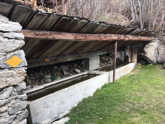
Along the Stigwasser irrigation channel, this hike first takes you from Mund into the Gredetschtal and via the Obersta irrigation channel to Birgisch. The irrigation channels, partly running through spectacular terrain and steep rock sections, are both dammed in the Gredetschtal at the Mundbach at about 1300 m above sea level and were used for a long time to irrigate fields and meadows in Mund and Birgisch.

Good to know
Pavements
Best to visit
Directions
The hike starts at the Mund Dorf bus stop and leads towards the church. From here, you pass through the narrow alleys of the typical Valais mountain village to the upper part of the village. At Tähischinu, the hiking trail network branches off. You take the right path and soon find yourself at the irrigation channel called Stigwasser. Follow the trail and you will soon reach the "Üssers Senntum" in the Gredetschtal. Here you cross the Mundbach and continue the hike along the path that follows the Obersta irrigation channel.
You walk through small, wild romantic tunnels and in the middle of the path, the Matterhorn appears on the horizon. Slowly, the valley opens up again and soon there is a clear view of the Rhone Valley. The path coming from Belalp takes you to the hamlet Oberbirgisch. From here, you follow a melioration road towards Birgisch. Via Mundchi, you return to Mund.
If you still have the desire and energy, you can visit the saffron museum in Mund and learn about the red gold.
Mund - Tähischinu - right path towards Stigwasser - Üssers Sänntum - Obersta - Birgisch - Mundchi - Mund
Tour information
Cultural Interesting
Loop Road
Stop at an Inn
Equipment
Sturdy footwear, weather-appropriate clothing, sun and rain protection, as well as sufficient supplies of food and drinks, are recommended in case there are no places to stop or buy along the way or they are closed. Although the path is very well marked throughout, you should always carry a suitable hiking map for safety reasons. Take poles or other aids with you.
Directions & Parking facilities
Arrival by car
From western Switzerland: A9 Lausanne - Vevey, or northwestern Switzerland: A12 Bern - Vevey: A9 - Sierre: main road Sierre - Brig
From northwestern Switzerland: A6 Bern - Thun - Spiez: main road Spiez - Kandersteg (car shuttle Lötschberg tunnel) - Goppenstein - Gampel - Brig
From eastern and central Switzerland: Andermatt - Realp (year-round car shuttle Furka; in summer via Furka pass) - Oberwald - Brig
From Ticino (in summer): Airolo - Nufenen pass - Ulrichen – Brig
Or via Centovalli – Domodossola – Simplon pass – Brig
From Italy (Aosta, Mt. Blanc Tunnel): Aosta - Grand Saint Bernard Tunnel (in summer via the pass) - Martigny: motorway A9 - Sierre: main road Sierre – Brig
Or via Domodossola – Simplon pass – Brig
Mund
From Brig, you reach Mund via Naters.
In Mund, opposite the church, there are some parking options.
Take the post bus to Mund Dorf and start your route there.
You can find the timetable and more information about getting there at: www.belalp.ch
Additional information
If you have questions, contact:
Belalp Bahnen AG
Blatten - Belalp Tourismus AG
Author´s Tip / Recommendation of the author
- Visit the saffron museum in Mund
- Enjoy the beautiful and unique view of the Matterhorn
Safety guidelines
Despite the "unmissable" marking of the hiking trails, we recommend always carrying an appropriate hiking map for safety reasons, so that you can quickly find a safe area in case of a thunderstorm or emergency.
Especially in autumn, note that leaves on the ground can conceal unevenness, roots, stones, or holes in the path. After storms, trees can still fall or branches drop later. Especially in adverse weather conditions, natural paths can have muddy and slippery sections. You should expect these types of trail impairments when hiking.
Not all rocks or precipices are secured with ropes or railings. Surefootedness is sometimes required. If you think certain sections of the path are not walkable for you, you should bypass them.
Nearby


Download GPX file