SALWALD-BRISCHERU CIRCULAR HIKE


- 2:15 h
- 5.74 km
- 471 m
- 470 m
- 1,592 m
- 2,063 m
- Difficulty: medium
- Start: Salwald
- Destination: Salwald
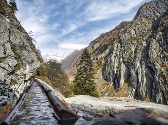
The hike starts leisurely in Salwald above Mund and initially leads to the settlement of Chaschtler. From Chaschtler, the actual ascent to Alpe Brischeru begins. Look back often and take a look at the Valais mountain world.
Arrived in Brischeru, a panorama opens from the Dents du Midi to the Goms. Enjoy the view of the mighty Fletschhorn, the Mischabel group, the Matterhorn, and the radiant Weisshorn.
Take a well-deserved break here before you start the descent to Salwald on the east side of Brischeru.

Good to know
Pavements
Best to visit
Directions
The hike starts in Salwald and first follows the signs to Chaschtler. From here, follow the signs again up to Alpe Brischeru. The descent is via the east side and the Horumattewald and from there down to the starting point of the hike.
Tour information
Loop Road
Stop at an Inn
Equipment
Sturdy footwear, weather-appropriate clothing, sun and rain protection, as well as sufficient supplies of food and drinks, should be taken along in case there are no opportunities to rest or shop or if they are closed. Although the path is consistently very well marked, for safety reasons you should always carry a suitable hiking map. Bring poles or other aids.
Directions & Parking facilities
Arrival by car
From Western Switzerland: A9 Lausanne - Vevey, or Northwest Switzerland: A12 Bern - Vevey: A9 - Sierre: main road Sierre - Brig
From Northwest Switzerland: A6 Bern - Thun - Spiez: main road Spiez - Kandersteg (car shuttle Lötschberg tunnel) - Goppenstein - Gampel - Brig
From Eastern and Central Switzerland: Andermatt - Realp (year-round car shuttle Furka; in summer via Furka pass) - Oberwald - Brig
From Ticino (in summer): Airolo - Nufenen pass - Ulrichen – Brig
Or via Centovalli – Domodossola – Simplon pass – Brig
From Italy (Aosta, Mt. Blanc Tunnel): Aosta - Grand Saint Bernard tunnel (in summer via the pass) - Martigny: highway A9 - Sierre: main road Sierre – Brig
Or via Domodossola – Simplon pass – Brig
Birgisch / Mund
From Brig you reach Birgisch, Mund and Salwald via Naters.
Park your car in Salwald.
Take the post bus to Mund village and start your route there. The hike to Salwald takes about 1 hour.
Author´s Tip / Recommendation of the author
Enjoy a fine saffron specialty at the Salwald restaurant.
Safety guidelines
Despite the "unmissable" marking of the hiking trails, we recommend always carrying a suitable hiking map for safety reasons so that, for example, you can quickly find a safe area in case of a thunderstorm or emergency.
Especially in autumn, you should also be aware that fallen leaves on the ground can hide unevenness, roots, stones, or holes in the path. After storms, trees can still fall or branches fall down afterwards. Particularly in adverse weather conditions, natural paths can have muddy and slippery sections. You should expect path impairments of this kind when undertaking a hike.
Not all rocks or precipices are secured with ropes or railings. Surefootedness is partly required. If you think that certain sections of the path are impassable for you, you should bypass them.
Nearby


Download GPX file