SUONEN CIRCULAR HIKE GREDETSCHTAL


- 2:50 h
- 7.46 km
- 349 m
- 350 m
- 1,201 m
- 1,514 m
- Difficulty: medium
- Start: Mund, bus stop (1203 m)
- Destination: Mund, bus stop (1203 m)
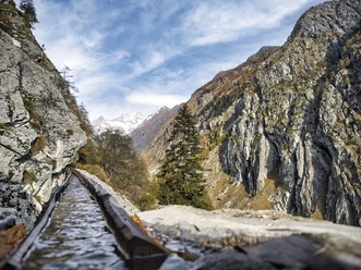
Along the spectacular Suone Wyssa, this hike first leads you from Mund along steep rock walls and through 16 tunnels onto the rocky meadows of the Gredetschtal. Wyssa was first mentioned in documents around 1462, and its builders had to attach it to the rock under difficult conditions.
In 1928/29 the Suone was restored and its course partly relocated into tunnels; in 1998, a modern water tunnel was built. This is located next to the entrance to the Suonen path and is an alternative for hikers who are not free from dizziness.
The hike back to Mund first follows the Mundbach and then branches off to the Suone Stigwasser. With minimal gradient, it goes along the Suone back to the starting point of the hike.
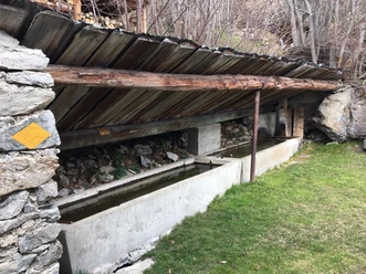
The Suonen, which pass through spectacular terrain and steep rock sections, are both collected in the Gredetschtal at the Mundbach at about 1,300 m above sea level and were long used for irrigating the fields and meadows in Mund and Birgisch.
Note
The path runs partly along steep rock escarpments and must therefore be approached with caution; being free from dizziness is required. Younger children should be roped in. You pass through several narrow tunnels, so a flashlight is practical.

Good to know
Pavements
Best to visit
Directions
The hike starts at the Mund Dorf bus stop and initially leads through the narrow alleys of the typical Valais mountain village to Roosse. Here the hiking trail network branches off. Continue in the direction of Suone Wyssa. Soon you will stand in front of the water tunnel built in 1998. For hikers who are not free from dizziness, it is recommended to use the route through the tunnel.
Follow the path and soon you will reach the "Üssers Senntum" in the Gredetschtal. Hike downstream along the Mundbach and continue the hike on the path that follows the Suone Stigwasser. This path will bring you back to Mund.
Mund - Dichtuhüs - Ewigschmatte - Üssers Senntum - Wyssa - Gredetschtal - Mundbach - Üssers Senntum - Breite Acher - Mund
Tour information
Cultural Interesting
Loop Road
Equipment
Sturdy footwear, weather-appropriate clothing, sun and rain protection, as well as sufficient provisions of food and drinks are recommended, as there might be no opportunities for stops or shopping or these may be closed. Although the path is very well marked throughout, for safety reasons, you should always carry a suitable hiking map. Take poles or other aids with you.
Directions & Parking facilities
Arrival by car
From Western Switzerland: A9 Lausanne - Vevey, or Northwestern Switzerland: A12 Bern - Vevey: A9 - Sierre: Main road Sierre - Brig
From Northwestern Switzerland: A6 Bern - Thun - Spiez: Main road Spiez - Kandersteg (car shuttle Lötschberg tunnel) - Goppenstein - Gampel - Brig
From Eastern and Central Switzerland: Andermatt - Realp (year-round car shuttle Furka; in summer via Furka Pass) - Oberwald - Brig
From Ticino (in summer): Airolo - Nufenen Pass - Ulrichen – Brig
Or via Centovalli – Domodossola – Simplon Pass – Brig
From Italy (Aosta, Mt. Blanc Tunnel): Aosta - Grand Saint Bernard Tunnel (in summer via the pass) - Martigny: Motorway A9 - Sierre: Main road Sierre – Brig
Or via Domodossola – Simplon Pass – Brig
Birgisch / Mund
From Brig you can reach Birgisch and Mund via Naters.
Take the post bus to Mund Dorf and start your route there.
The schedule and further information about arrival can be found at: www.belalp.ch
Additional information
If you have any questions, please contact:
Belalp Bahnen AG
www.belalp.ch
bahnen@belalp.ch
+41 27 921 65 10
Blatten - Belalp Tourismus AG
tourismus@belalp.ch
+41 27 921 60 40
Author´s Tip / Recommendation of the author
Visit the Saffron Museum in Mund.
A flashlight is recommended for exploring the tunnels.
Safety guidelines
The path runs along the Suonen partly on steep rock faces and must therefore be approached with caution; being free from dizziness is required. You pass through several narrow tunnels, so a flashlight is practical.
Despite the "infallible" marking of the hiking trails, we recommend that for safety reasons you always carry an appropriate hiking map so that, for example, in the event of a thunderstorm or emergency, you can quickly find a safe area.
Especially in autumn, care must be taken as fallen leaves on the ground can hide unevenness, roots, stones, or holes in the path. After storms, trees may still fall or branches may break off. Especially under adverse weather conditions, natural paths can have muddy and slippery sections. You must expect path impairments of this kind when undertaking a hike.
Not all rocks or cliffs are secured with ropes or railings. Surefootedness is partly required. If you think certain sections of the path are not passable for you, you should bypass them.
Nearby


Download GPX file