CIRCULAR HIKE BLATTEN - GIBIDUM RESERVOIR - RISCHINER FOREST


- 1:45 h
- 4.78 km
- 270 m
- 272 m
- 1,328 m
- 1,484 m
- Difficulty: easy
- Start: Blatten bei Naters
- Destination: Blatten bei Naters
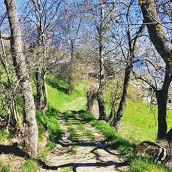
The circular hike initially follows the paved road to the Gibidum reservoir. The Gibidum reservoir, with an area of 21 hectares (approximately 29 football fields), was completed in 1967 and is fed by the Great Aletsch Glacier. You reach the dam via a steel stairway. On the return, the hike takes you through the mystical Rischiner forest. Let your gaze wander and enjoy the tranquility.
A varied hike for the whole family.

Good to know
Pavements
Best to visit
Directions
The hike starts at the Blatten bei Naters, cable car post bus stop. Follow the signs towards the Gibidum reservoir along the road. Cross the dam and head downhill until you reach the metal bridge over the Massa. Here the trail leads back towards Blatten bei Naters. Take the first curve onto the hiking trail and walk through the forest back to Blatten bei Naters.
Route description
Blatten bei Naters - Gibidum reservoir - Rischiner forest – Blatten bei Naters
Tour information
Loop Road
Equipment
Sturdy footwear, weather-appropriate clothing, sun and rain protection, as well as sufficient supplies of food and drinks are recommended in case no dining or shopping options are available or open. Although the path is very well marked throughout, for safety reasons you should always have a suitable hiking map with you. Bring poles or other aids.
Directions & Parking facilities
Arrival by car
From Western Switzerland: A9 Lausanne - Vevey, or Northwest Switzerland: A12 Bern - Vevey: A9 - Sierre: Main road Sierre - Brig
From Northwest Switzerland: A6 Bern - Thun - Spiez: Main road Spiez - Kandersteg (car shuttle Lötschberg tunnel) - Goppenstein - Gampel - Brig
From Eastern and Central Switzerland: Andermatt - Realp (year-round Furka car shuttle; in summer via Furka pass) - Oberwald - Brig
From Ticino (in summer): Airolo - Nufenen pass - Ulrichen – Brig
Or via Centovalli – Domodossola – Simplon pass – Brig
From Italy (Aosta, Mt. Blanc Tunnel): Aosta - Grand Saint Bernard tunnel (in summer via the pass) - Martigny: motorway A9 - Sierre: Main road Sierre – Brig
Or via Domodossola – Simplon pass – Brig
Blatten bei Naters
From Brig you reach Blatten bei Naters via Naters and then take the cable car to the car-free Belalp.
Paid parking spaces are available in Chienzlichrommu and in the car park in Blatten bei Naters.
Further information is available at:
Blatten bei Naters is reachable by public transport from Brig or Naters.
Timetables and further travel information can be found at: www.belalp.ch
Additional information
If you have any questions, please contact:
Belalp Bahnen AG
Blatten - Belalp Tourism AG
Author´s Tip / Recommendation of the author
Guess how many steps there are up to the dam.
Enjoy the Rischiner forest and have a picnic.
Safety guidelines
Despite the "unmissable" marking of the hiking trails, for safety reasons it is always recommended to have a suitable hiking map with you so that in the event of a thunderstorm or emergency you can quickly find a safe area.
Especially in autumn, note that fallen leaves on the ground can conceal unevenness, roots, stones, or holes in the path. After storms, trees may still fall or branches drop. In adverse weather conditions, natural trails can have muddy and slippery sections. You should expect such trail disruptions when hiking.
Not all rocks or cliffs are secured with ropes or railings. Sometimes sure-footedness is required. If you believe certain trail sections are impassable for you, you should bypass them.
Nearby


Download GPX file