


- 0:55 h
- 2.60 km
- 157 m
- 157 m
- 680 m
- 836 m
- 156 m
- Start: Naters (680 m)
- Destination: Naters (680 m)
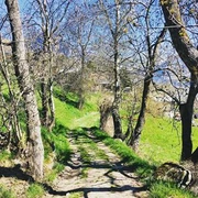
This short and easy hike leads from Naters up to the Bellavista and back again. You hike along old paths and escape from everyday life despite the proximity to Brig and Naters. Enjoy the view of the valley.

Good to know
Pavements
Best to visit
Directions
Naters - Old village - Klosi - Bellavista - Stahlgasse - Old village - Naters
Tour information
Cultural Interesting
Loop Road
Stop at an Inn
Equipment
Directions & Parking facilities
From western Switzerland: A9 Lausanne - Vevey, or north-western Switzerland: A12 Bern - Vevey: A9 - Sierre: main road Sierre - Brig
From north-western Switzerland: A6 Berne - Thun - Spiez: main road Spiez - Kandersteg (Lötschberg tunnel car transport) - Goppenstein - Gampel - Brig
From eastern and central Switzerland: Andermatt - Realp (year-round Furka car transport; in summer via Furka Pass) - Oberwald - Brig
From Ticino (in summer): Airolo - Nufenenpass - Ulrichen - Brig
Or via Centovalli - Domodossola - Simplonpass - Brig
From Italy (Aosta, Mt. Blanc Tunnel): Aosta - Grand Saint Bernard tunnel (over the pass in summer) - Martigny: A9 motorway - Sierre: Sierre - Brig main road.
Or via Domodossola - Simplon Pass - Brig
You can also walk directly from Brig through Naters and start your tour that way.
Author´s Tip / Recommendation of the author
Safety guidelines
Especially in autumn, you should also be aware that leaves lying on the ground can hide bumps, roots, stones or holes in the path. After storms, trees can still fall over or branches can fall down. Especially in adverse weather conditions, muddy and slippery passages can occur on natural paths. You have to expect this kind of damage to paths when you go on a hike.
Not all rocks or precipices are secured with ropes or railings. In some cases surefootedness is required. If you are of the opinion that certain sections of the trail are not passable for you, you should avoid them.
Nearby


