VERONICA'S JUNGLE


- 1:10 h
- 2.65 km
- 208 m
- 206 m
- 1,327 m
- 1,519 m
- 192 m
- Start: Blatten bei Naters (1326 m)
- Destination: Blatten bei Naters
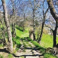
The path to the Burgen viewpoint in Blatten near Naters leads through the Chastelwald forest. Discover an unspoilt primeval forest right on the edge of the village of Blatten near Naters. Fallen trees, moors and lots of forest dwellers await you.
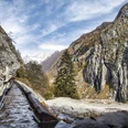
Once you reach the castles, you can enjoy a wonderful view of the village of Blatten bei Naters. From there you return to the junction where the path leads back to Blatten on the other side of the forest.
As it is very shady and damp in the forest, we recommend that you wear good shoes. Watch out for the wet roots - they can be slippery.
To ensure that the natural forest reserve remains unspoilt, we ask you not to leave the hiking trails. The natural development of the forest is deliberately allowed to return to around 60 hectares. As the forest is not used for forestry, the trees can reach their biological age. For example, spruces can live up to 700 years and larches up to 1000 years.
Over time, the forest forms all phases of development. Above all, build-up and decay phases. This specifically promotes biodiversity. For visitors, this is an intensive nature experience of an unusual kind.

Good to know
Pavements
Best to visit
Directions
The hike begins at the valley station of the Belalp cable cars and first leads briefly along the road to the first bend. Here you leave the road and cross the bridge over the Bruchji. Follow the signs in the direction of the castles. The trail leads through the Chastelwald forest up to the Burgen viewpoint. Once at the top, enjoy the view of the village before continuing along the path and returning to the starting point of the hike.
Blatten - Chastelwald - Burgen - Blatten
Tour information
Barrier-Free
Loop Road
Stop at an Inn
Equipment
Directions & Parking facilities
From western Switzerland: A9 Lausanne - Vevey, or north-western Switzerland: A12 Bern - Vevey: A9 - Sierre: main road Sierre - Brig
From north-western Switzerland: A6 Berne - Thun - Spiez: main road Spiez - Kandersteg (Lötschberg tunnel car transport) - Goppenstein - Gampel - Brig
From eastern and central Switzerland: Andermatt - Realp (year-round Furka car transport; in summer via Furka Pass) - Oberwald - Brig
From Ticino (in summer): Airolo - Nufenenpass - Ulrichen - Brig
Or via Centovalli - Domodossola - Simplonpass - Brig
From Italy (Aosta, Mt. Blanc Tunnel): Aosta - Grand Saint Bernard tunnel (over the pass in summer) - Martigny: A9 motorway - Sierre: Sierre - Brig main road.
Or via Domodossola - Simplon Pass - Brig
Blatten bei Naters
From Brig you can reach Blatten bei Naters via Naters, then take the cable car to the car-free Belalp.
You can find more info at:
Timetable at: www.belalp.ch
Additional information
If you have any questions, please contact:
Belalp Bahnen AG
Blatten - Belalp Tourismus AG
Author´s Tip / Recommendation of the author
Enjoy the magnificent panorama and linger at the lookout point.
Discover and experience Veronika's primeval forest in the Chastelwald with all your senses.
Safety guidelines
Despite the "impossible to miss" marking of the hiking trails, we recommend for safety reasons to always have an appropriate hiking map with you so that you can quickly find your way to a safe area in case of a thunderstorm or emergency, for example.
Especially in autumn, you should also be aware that leaves lying on the ground can hide bumps, roots, stones or holes in the path. After storms, trees can still fall over or branches can fall down. Especially in adverse weather conditions, muddy and slippery passages can occur on natural paths. You have to expect this kind of damage to paths when you go on a hike.
Not all rocks or precipices are secured with ropes or railings. In some cases surefootedness is required. If you are of the opinion that certain sections of the trail are not passable for you, you should avoid them.
Nearby


