VERONIKA'S PRIMEVAL FOREST


- 1:10 h
- 2.65 km
- 208 m
- 206 m
- 1,327 m
- 1,519 m
- Difficulty: easy
- Start: Blatten near Naters (1326 m)
- Destination: Blatten near Naters
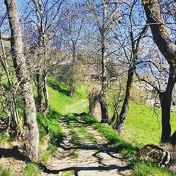
The path to the Burgen viewpoint in Blatten near Naters goes through the Chastelwald. Discover an untouched primeval forest right on the edge of the village of Blatten near Naters. Fallen trees, bogs, and lots of forest inhabitants await you.
Arriving at Burgen, enjoy a wonderful view of the village of Blatten near Naters. From there you return to the junction where the path on the other side of the forest leads back to Blatten.
Since it is very shady and damp in the forest, we recommend good footwear. Watch out for wet roots - they can be slippery.
To keep the natural forest reserve untouched, please do not leave the hiking trails. On around 60 hectares the natural development of the forest is consciously allowed to continue. As the forest is not used for forestry, the trees can reach their biological age. Spruces can live up to 700 years and larches up to 1000 years old.
Over time the forest develops all phases of development, especially growth and decay phases. This deliberately promotes biodiversity. For visitors, an intense nature experience of an unusual kind.

Good to know
Pavements
Best to visit
Directions
The hike starts at the valley station of the Belalp cable cars and initially follows the road briefly to the first curve. Here you leave the road and cross the bridge over the Bruchji. Follow the signs towards Burgen. The path goes through the Chastelwald up to the Burgen viewpoint. Once at the top, enjoy the view of the village before continuing the path and returning to the starting point of the hike.
Blatten - Chastelwald - Burgen - Blatten
Tour information
Barrier-Free
Loop Road
Stop at an Inn
Equipment
Sturdy footwear, weather-appropriate clothing, sun and rain protection, as well as enough supplies of food and drinks should be carried in case there are no opportunities to eat or shop open. Although the path is very well marked throughout, for safety reasons you should always carry a suitable hiking map. Bring poles or other aids.
Directions & Parking facilities
Arrival by car
From western Switzerland: A9 Lausanne - Vevey, or northwestern Switzerland: A12 Bern - Vevey: A9 - Sierre: main road Sierre - Brig
From northwestern Switzerland: A6 Bern - Thun - Spiez: main road Spiez - Kandersteg (car shuttle Lötschberg tunnel)- Goppenstein - Gampel - Brig
From eastern and central Switzerland: Andermatt - Realp (year-round car shuttle Furka; in summer via Furka pass) - Oberwald - Brig
From Ticino (in summer): Airolo - Nufenenpass - Ulrichen – Brig
Or via Centovalli – Domodossola – Simplonpass – Brig
From Italy (Aosta, Mt. Blanc Tunnel): Aosta - Grand Saint Bernard tunnel (in summer via the pass) - Martigny: motorway A9 - Sierre: main road Sierre – Brig
Or via Domodossola – Simplonpass – Brig
Blatten near Naters
From Brig you reach Blatten near Naters via Naters, then take the aerial cable car to the car-free Belalp.
Parking with fees is available at Chienzlichrommu and in the parking garage in Blatten near Naters.
For more information, visit:
Blatten near Naters is accessible by public transport from Brig or Naters.
Timetable at: www.belalp.ch
Additional information
If you have questions, contact:
Belalp Bahnen AG
bahnen@belalp.ch
+41 (0)27 921 65 10
Blatten - Belalp Tourism AG
tourismus@belalp.ch
+41 (0)27 921 60 40
Author´s Tip / Recommendation of the author
Enjoy the magnificent panorama and linger at the viewpoint.
Discover and experience Veronika's primeval forest in the Chastelwald with all your senses.
Safety guidelines
Despite the "unmissable" markings of the hiking trails, we recommend for safety reasons always carrying an appropriate hiking map so that, for example in the event of a thunderstorm or emergency, you can quickly find a safe area.
Especially in autumn, note that leaves on the ground can cover unevenness, roots, stones, or holes in the path. After storms, trees may still fall or branches may break off. Especially in adverse weather, natural paths can become muddy and slippery. You should expect such trail impairments when hiking.
Not all rocks or cliffs are secured with ropes or railings. Surefootedness is sometimes required. If you believe certain sections are impassable for you, you should bypass them.
Nearby


Download GPX file