HISTORIC ROAD


- 2:18 h
- 5.70 km
- 657 m
- 5 m
- 676 m
- 1,333 m
- Difficulty: medium
- Start: Naters Marktplatz (680 m)
- Destination: Blatten bei Naters (1327m)
The old mountain road between Naters and Blatten bei Naters is a historic path primarily recognizable for its traditional appearance and its architectural substance.
The so-called "old mountain road" leads from Naters to Klosi and then uphill to Moos, Geimen, Mehlbaum, and Blatten bei Naters. The old mountain road dates back to the penultimate millennium turn.
It is gently embedded in the cultural landscape of the Natischer mountain. The path is characterized by alleys, hollow and slope paths, embankments, dry stone walls, freestanding path boundaries, boundary stones, wooden fences, stone paving, transverse slopes, mule troughs, and the like. The old mountain road was primarily used as a pack trail and for driving livestock. In many places, the excellent historical building fabric has been preserved.

Good to know
Pavements
Best to visit
Directions
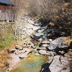
From the Naters Marktplatz stop, go through narrow lanes, past the noteworthy ossuary, the parish church, and the Junkerhof. Follow the road uphill and you will reach the Klosi, where the path to Blatten bei Naters branches off to the right. On the way, in the section between Moos and Obermoos, a mule trough carved in stone is visible on the left side. After passing through Geimen, continue the ascent towards Blatten bei Naters. Follow the historic road and enjoy the waterfall at Mehlbaum. Soon you will arrive at Blatten bei Naters Ahorn and from here again take the historic road into the Old Village.
Naters - Moos - Geimen - Mehlbaum - Blatten bei Naters
Tour information
Cultural Interesting
Equipment
Sturdy footwear, weather-appropriate clothing, sun and rain protection, as well as a sufficient supply of food and drinks, should be carried in case no dining or shopping options are available or open. Although the path is very well marked throughout, for safety reasons you should always have a suitable hiking map with you. Bring poles or other aids.
Directions & Parking facilities
Arrival by car
From Western Switzerland: A9 Lausanne - Vevey, or Northwestern Switzerland: A12 Bern - Vevey: A9 - Sierre: main road Sierre - Brig
From Northwestern Switzerland: A6 Bern - Thun - Spiez: main road Spiez - Kandersteg (car shuttle Lötschberg tunnel) - Goppenstein - Gampel - Brig
From Eastern and Central Switzerland: Andermatt - Realp (year-round car shuttle Furka; in summer over Furka pass) - Oberwald - Brig
From Ticino (in summer): Airolo - Nufenen pass - Ulrichen – Brig
Or via Centovalli – Domodossola – Simplon pass – Brig
From Italy (Aosta, Mt. Blanc Tunnel): Aosta - Grand Saint Bernard Tunnel (in summer over the pass) - Martigny: highway A9 - Sierre: main road Sierre – Brig
Or via Domodossola – Simplon pass – Brig
Blatten bei Naters
From Brig you reach Blatten bei Naters via Naters, and then by cable car to the car-free Belalp.
Naters
In both Naters and Brig, several paid parking spaces and parking garages are available.
Blatten-Belalp
Paid parking spaces are available at Chienzlichrommu and the parking garage in Blatten bei Naters.
Further information can be found at:
Naters
Take the PostBus or the local bus (line 1) from Brig to Naters Marktplatz and start your route there.
You can also start your route directly by walking through Naters from Brig.
Blatten-Belalp
Blatten bei Naters is accessible by public transport from Brig or Naters.
You can reach Belalp from Blatten by cable car.
Timetable and more travel information can be found at: www.belalp.ch
Additional information
For questions, please contact:
Belalp Bahnen AG
Blatten - Belalp Tourismus AG
Literature
Author´s Tip / Recommendation of the author
Enjoy the many sunny spots for relaxing.
Admire the art and the church in Geimen.
Safety guidelines
Despite the "unmissable" marking of the hiking trails, we recommend always carrying an appropriate hiking map for safety reasons, so that in case of a thunderstorm or emergency you can quickly find a safe area.
Especially in autumn, be aware that fallen leaves on the ground may conceal unevenness, roots, stones, or holes in the path. After storms, trees may still fall or branches may drop. Especially under adverse weather conditions, natural paths can have muddy and slippery sections. You must expect such trail impairments when hiking.
Not all rocks or precipices are secured with ropes or railings. Some sections require sure-footedness. If you feel that certain sections are impassable for you, you should bypass them.
Map
Nearby


