WINTER HIKING ROUTE BRUCHEGG - SCHÖNBIEL


- 0:45 h
- 831 m
- 161 m
- 2,140 m
- 2,300 m
- Difficulty: easy
- Start: Bruchegg, Belalp
- Destination: Schönbiel, Belalp
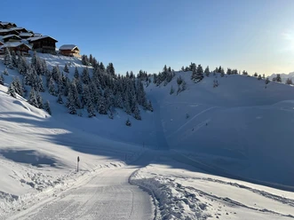
The winter hike starts at the Sparrhorn chairlift valley station towards Schönbiel (2300 m above sea level). Below the chairlift, go to the left side. From here, follow the path up to the Schönbiel mountain station. The winter hiking route is located next to the downhill slope. The hike takes approximately 45 minutes.
Once at Schönbiel, you can enjoy the sunshine and a refreshment at Ricco's igloo. From Schönbiel, you have a wonderful panoramic view of the wintery Belalp and the Valais mountains.
For the return journey, there are several options. You can return to the starting point of your winter hike by chairlift Bruchegg or via the winter hiking path. If you want to descend to Chiematte and the mountain station of the gondola, you can either use the Kelchbach chairlift or descend via the winter hiking path Weisse Meile.

Good to know
Pavements
Best to visit
Directions
Tour information
Stop at an Inn
Equipment
Sturdy footwear, weather-appropriate clothing, sun and rain protection, as well as sufficient supplies of food and drinks are recommended in case no inns or shopping facilities are available or open. Although the path is consistently well marked, for safety reasons you should always carry a suitable hiking map. Bring poles or other aids.
Directions & Parking facilities
Arrival by car
From Western Switzerland: A9 Lausanne - Vevey, or from Northwestern Switzerland: A12 Bern - Vevey: A9 - Sierre: main road Sierre - Brig
From Northwestern Switzerland: A6 Bern - Thun - Spiez: main road Spiez - Kandersteg (car shuttle Lötschberg tunnel) - Goppenstein - Gampel - Brig
From Eastern and Central Switzerland: Andermatt - Realp (year-round car shuttle Furka; in summer via Furka pass) - Oberwald - Brig
From Ticino (in summer): Airolo - Nufenen pass - Ulrichen – Brig
Or via Centovalli – Domodossola – Simplon pass – Brig
From Italy (Aosta, Mt. Blanc tunnel): Aosta - Grand Saint Bernard tunnel (in summer via the pass) - Martigny: motorway A9 - Sierre: main road Sierre – Brig
Or via Domodossola – Simplon pass – Brig
Blatten bei Naters
From Brig, you reach Blatten bei Naters via Naters, then take the aerial cableway to the car-free Belalp.
Paid parking is available at Chienzlichrommu and in the parking garage in Blatten bei Naters.
Further information can be found at: www.belalp.ch
Blatten bei Naters is accessible by public transport from Brig or Naters. You can reach Belalp from Blatten by aerial cableway.
Timetables and further travel information can be found at: www.belalp.ch
Additional information
Author´s Tip / Recommendation of the author
Relax at Ricco's igloo and enjoy a fine coffee.
Safety guidelines
Use of the snowshoe trails and the information on this website is at your own risk. Conditions on site may cause changes to the route. Blatten-Belalp Tourism takes no responsibility for the accuracy and completeness of the information on this website.
- Carry a map with you. Download the complete description of the hiking trail with a large-scale map by clicking on "Print" at the top right of the page.
- Use only marked trails and follow all signposts and instructions – for your own safety, to protect grazing animals, and out of respect for wildlife.
- Be considerate of other trail users and the environment. Take your trash and that of others with you.
- Bring additional sun protection. UV rays at high altitudes can be especially strong in winter, even in cloudy weather.
Nearby


