GÄRSTHORN


- 6:30 h
- 5.06 km
- 1,329 m
- 8 m
- 1,599 m
- 2,920 m
- Difficulty: difficult
- Start: Salwald
- Destination: Salwald
The hike to the Gärsthorn is demanding, but the view from the summit compensates for all the hardships.
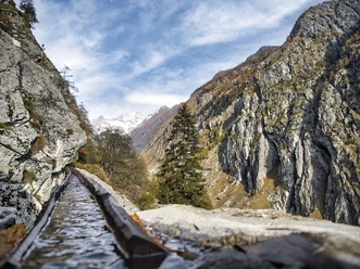
You can drive to the Salwald restaurant. From there, the ascent begins towards the Alpe Brischeru and further up to the summit. The path is marked red and white up to Brischeru, and from there to the summit it is a mountain trail marked blue and white. The hike leads through larch forests, over alpine meadows, and finally over a rocky, rather steep ascent to the summit. An experience for all experienced hikers!

Good to know
Pavements
Best to visit
Directions
From the Salwald restaurant, you ascend over the Sättli to the Alpe Brischeru. Alternatively, you can also take the path via the Horumatte. At the last huts of Brischeru, the path branches off to the left and leads up to the Chiematte and further to the Gärsthalte. You have now left the tree line behind you, and the path from Brischeru is marked blue and white (mountain trail). Follow the trail markings over the grassy meadows to the cross at "Gämscherlibiel." From there, the path becomes increasingly rocky and steadily rises up to the summit cross. The panorama from above compensates for every drop of sweat.
The descent follows the same route. As an alternative, you can descend from Alpe Brischeru via the Horumatte to the Salwald restaurant. This path passes the chapel at Brischeru and is well signposted.
The hike can also of course be started in Mund (post bus stop). The hiking time is extended by approximately 2 hours and 15 minutes.
Tour information
Stop at an Inn
Summit
Equipment
Sturdy footwear, weather-appropriate clothing, sun and rain protection, as well as a sufficient supply of food and drinks, should be carried in case no rest or shopping facilities are available or open. The trail is partially marked blue and white. For safety reasons, you should always carry a suitable hiking map. Poles can make hiking easier.
Directions & Parking facilities
Arrival by car
From western Switzerland: A9 Lausanne - Vevey, or northwest Switzerland: A12 Bern - Vevey: A9 - Sierre: main road Sierre - Brig
From northwest Switzerland: A6 Bern - Thun - Spiez: main road Spiez - Kandersteg (car transport Lötschberg tunnel) - Goppenstein - Gampel - Brig
From eastern and central Switzerland: Andermatt - Realp (year-round car transport Furka; in summer via Furka pass) - Oberwald - Brig
From Ticino (in summer): Airolo - Nufenenpass - Ulrichen – Brig
Or via Centovalli – Domodossola – Simplon pass – Brig
From Italy (Aosta, Mt. Blanc tunnel): Aosta - Grand Saint Bernard tunnel (in summer via the pass) - Martigny: highway A9 - Sierre: main road Sierre – Brig
Or via Domodossola – Simplon pass – Brig - Birgisch / Mund
From Brig you can reach Birgisch and Mund via Naters.
Parking is available at the Salwald restaurant or slightly above in the Äbi.
Take the post bus to Mund Dorf and start your route there.
You can find the timetable and more information about the journey at: www.sbb.ch
The Salwald restaurant can only be reached by car.
Author´s Tip / Recommendation of the author
The "Gämscherlibiel" is an ideal resting place. It is worth taking a break here to gain strength for the steep ascent to the summit.
Please sign the summit book.
Safety guidelines
Despite the "unmissable" marking of the hiking trails, we recommend always carrying a suitable hiking map for safety, so that in case of a thunderstorm or emergency you can quickly find a safe area.
Especially in autumn, be aware that fallen leaves on the ground can conceal uneven surfaces, roots, stones, or holes in the path. After storms, trees can still fall or branches fall down subsequently. In poor weather conditions, natural paths can have muddy and slippery sections. You must expect such path impairments when hiking.
Not all rocks or cliffs are secured with ropes or railings. Surefootedness is sometimes required. If you think certain sections of the path are not passable for you, you should avoid them.
Nearby


